
SEMINAIRE: Surface representation impacts on turbulent heat fluxes in WRF
par Carlos Román-Cascón, mercredi 16 décembre 2020 à 10h00, en visio-conférence: https://greenlight.lal.cloud.math.cnrs.fr/b/lam-xmr-vza
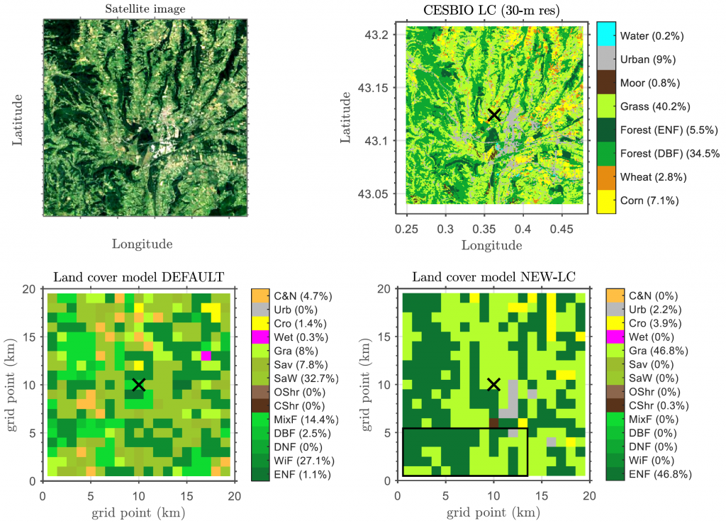
The water and energy transfers at the interface between the Earth’s surface and the atmosphere should be correctly simulated in numerical weather and climate models. This implies the need for a realistic and accurate representation of land cover (LC), including appropriate parameters for each vegetation type. In some cases, the lack of information and crude representation of the surface leads to errors in the simulation of soil and atmospheric variables. This work investigates the ability of the Weather Research and Forecasting (WRF) model to simulate surface heat fluxes in a heterogeneous area of southern France, using several possibilities for the surface representation. In the control experiments, we used the default LC database in WRF, which differed significantly from the actual LC. In addition, sub-grid variability was not considered since the model uses, by default, only the surface information from the dominant LC category in each pixel (dominant approach). To improve this surface simplification, we designed three new interconnected numerical experiments with four widely used land-surface models (LSMs) in WRF. The first one consisted of using a more realistic and higher-resolution LC dataset over the area of analysis. The second experiment aimed at investigating the effect of using a mosaic approach, where 30-m sub-grid surface information was used to calculate the final grid fluxes, based on weighted averages from values obtained for each LC category. Finally, in the third experiment, we increased the model stomatal conductance for conifer forests, due to the large fluxes errors associated with this vegetation type in some LSMs. The simulations were evaluated with gridded area-averaged fluxes calculated from five tower measurements obtained during the Boundary Layer Late Afternoon and Sunset Turbulence (BLLAST) field campaign. The results from the experiments differed depending on the LSM and displayed a high dependency of the simulated fluxes on the specific LC definition within the grid cell, an effect that was enhanced with the dominant approach. The simulation of the fluxes improved using the more realistic LC dataset except for the LSMs that included extreme surface parameters for the coniferous forest. The mosaic approach produced fluxes more like reality and served to improve, especially, the latent heat flux simulation of each grid cell. Therefore, our findings stress the need to include an accurate surface representation in the model, including soil and vegetation sub-grid information with updated surface parameters for some vegetation types, as well as seasonal and man-made changes. This will improve the modelled heat fluxes and ultimately yield more realistic atmospheric processes in the model.
Román-Cascón, Carlos1,2; Lothon, Marie2; Lohou, Fabienne2; Hartogensis, Oscar3; Vila-Guerau de Arellano, Jordi3, Pino, David4; Yagüe, Carlos5; and Pardyjak, Eric R.6
1 Centre National d’Études Spatiales (CNES), 31400 Toulouse, France; 2 Laboratoire d’Aérologie, CNRS, Université de Toulouse, 31400 Toulouse, France; 3 Meteorology and Air Quality Section, Wageningen University, Wageningen, Netherlands; 4 Department of Physics, Universitat Politècnica de Catalunya-BarcelonaTech, 08034 Barcelona, Spain; 5 Departamento de Física de la Tierra y Astrofísica. Universidad Complutense de Madrid, 28040 Madrid, Spain; 6 Department of Mechanical Engineering, University of Utah, Salt Lake City, UT, USA.